
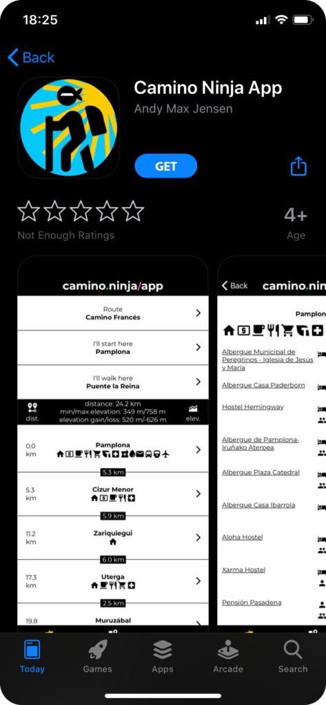
Camino Ninja App is out for iPhone and iPad on Apple App Store.
https://apps.apple.com/us/app/camino-ninja-app/id1491232190
Camino Ninja App is out for iPhone and iPad on Apple App Store.
https://apps.apple.com/us/app/camino-ninja-app/id1491232190
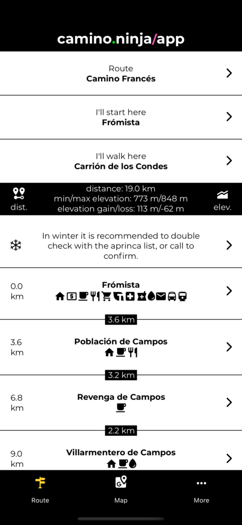
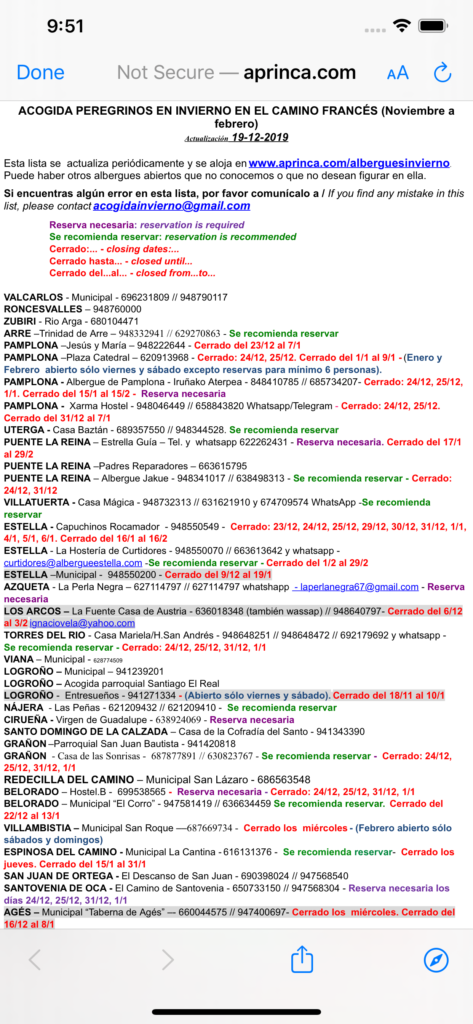
In winter it is a good idea to either check if albergues and other accommodation is really open even if they are supposed to. There is a list being updated almost every day, by a woman from Fromista, from November to February. The list is only for Camino Francés. Either check that list or call the place to see if the place is open. The list does not contain all open albergues, but a lot. I added a link to the list from the dashboard of the App.
Being able to navigate in spots without or with limited cellular coverage can be essential as a traveler. ‘
A Camino App with offline and data-saving features greatly helps with that. All the information about routes, locations, accommodations, distances and calculations are stored in the App and are available offline.
I do not want to encourage anyone to travel anywhere without a phone and a subscription that works for both calls and data. That goes for both cities and nature. That being said, the caminos in Spain are some of the safest places to travel in the world and walking solo is feasible with the App. But when you are in a foreign country and might not speak the language, you want to be as prepared as possible. For walking the camino it is practical to be able to make phone calls for reservations or sometimes just to verify the place you are going to is open, as well as calling a taxi or emergency services if needed. Data also makes it possible to complete instant bookings when the albergue you just passed is full, for example, or to research, navigate, and stay in touch with family and friends. Wi-Fi can be slow or unavailable in many places along the route, including albergues and hostels.
I really love nice and crisp images that are optimized for that particular phone you are using, like on Instagram. So that is already in the App. But if you are researching a lot of accommodation options and using lots of data on a limited subscription, it might not be what you want.
So, I made a new option for showing images in a lower resolution. Actually, the image size is only about 10% of the original, optimized crispy image …and the best part …you can hardly tell the difference. The higher resolution images are still shown when you are on Wi-Fi.
The second option for images allows you to turn off images completely, unless you are on Wi-Fi. Another way of not having images shown and not use unwanted amounts of data is to put your phone in airplane mode when you are walking and just enabling Wi-Fi when you are making a break at a café or at night at your chosen accommodation.
The Routes and Locations in the App are probably the most precise of all the Apps and websites out there.
Most of the time maps are not necessary to use, but they are helpful in bigger cities where finding the route can be more difficult, when you are tired and have to find your accommodation, or if you by mistake lose your way on the route (it still happens to me sometimes).
Having an offline map like MAPS.ME can come in handy, especially if there is no cellular coverage wherever you are.
I did not make offline maps in the App, but I made the App support them. Re-doing the whole MAPS.ME functionality would require downloading big amounts of data to your phone, so to save you more GBs to take Camino pictures I came up with the solution to link to MAPS.ME instead. And for me it really works.
Offline maps are not really necessary for most people, but if you want that extra security and have space on your phone to download the maps, it can come in handy.
Maps are getting their map tiles (backgrounds) online. To save you data while walking the route, I made an option for hiding the Maps shown normally when viewing details about cities and accommodations while on cellular data.
I also made another option to show a link to MAPS.ME so you can use it instead of the build-in Map for finding your accommodation while being offline. Please note that the build-in Map is most likely more precise for everything else and therefore, the recommended one to use.
Currently the Elevation Chart only works online.
Distance works offline and in airplane mode. Your GPS has to be enabled but it should be by default.
You can find the new settings in the App under More -> Offline & Data-Saving Settings.
Try it and tell me what you think. You can catch me on Facebook or Instagram if you have any questions or comments.
Buen Camino!
The Camino Ninja App is now available for Android Phones. Camino Ninja App is free to use, free of ads, and frees you to walk your Camino, your way.
You can get the Android version of the App right now, here:
https://camino.ninja/app
The iPhone version of the App will be out next year. If you want to receive a notification when the iPhone version is out, sign up here:
https://camino.ninja/app/iphone
The Camino de Santiago routes— Camino Francés, Caminho Português, the Camiños a Fisterra (Finisterre) and Muxía, and the way between Fisterra and Muxía are in the App as well as Camino San Salvador and Camino Primitivo.
The Camino Ninja App has extensive and precise tracking of the routes, elevations, and accommodation locations. It is intuitive, easy to use, and simple to plan your route from place to place using stages and distances you can easily cater to match your daily needs, weather, and circumstances. I walked over 15.000 km of the Camino routes in the past 3 years, and for the last 1½ years I have been working on making an App that supports walking the Caminos the best way possible.
Early testers of the App said it was exactly what they needed for planning their way—everything is accessible from a few tabs from the dashboard and the precision of the GPS works better than other apps.
Photos of albergues, hostels, and hotels along the route give you a visual taste of the places you are going to stay and booking if you choose is seamless and easy in the App…and it’s entirely free.
New features, enhancements, and more optimized routes are also currently in progress to make the App even easier to use and more useful on your Camino.
I hope you like the App. If you have feedback or comments, my contact details are in the App or you can catch me on Facebook or Instagram.